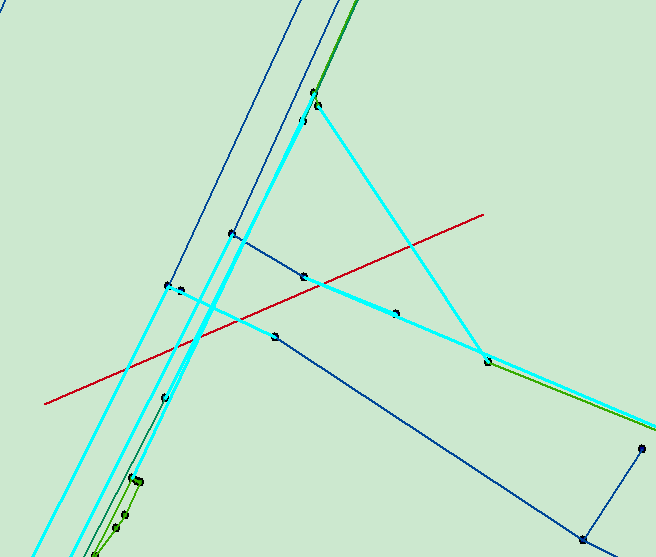
1工具效果展示:画线,选择与该线相交的要素并高亮显示

2代码实现
开发环境: c# 2010、 arcengine 10.1、 win7
思路:在mapcontrol中画一条线(INewLineFeedback接口),并显示;用map的SelectByShape方法选择要素。
步骤:
a 在项目中添加BaseTool类,命名T_Tool.cs
b 在T_Tool中添加:INewLineFeedback m_displayFeedback = null 用于追踪鼠标所画的线段。
c 在OnMouseDown、OnMouseMove方法下面,实现画线操作
d 在OnDblClick()下结束画线,并显示要素。
代码:(OnMouseDown)
          pPoint = m_mapControl.ActiveView.ScreenDisplay.DisplayTransformation.ToMapPoint(X, Y);
          if (m_displayFeedback == null)
            {
                m_displayFeedback = new NewLineFeedbackClass();
                ISimpleLineSymbol pLine = m_displayFeedback.Symbol as ISimpleLineSymbol;
                RgbColorClass pColor=new RgbColorClass();
                pColor.Red=255;
                pColor.Green=0;
                pColor.Blue=0;
                pLine.Color = pColor;
                m_displayFeedback.Display = m_mapControl.ActiveView.ScreenDisplay;
                m_displayFeedback.Start(pPoint);
            }
            else
            {
                m_displayFeedback.AddPoint(pPoint);
            }
在OnMouseMove下:
           pPoint = m_mapControl.ActiveView.ScreenDisplay.DisplayTransformation.ToMapPoint(X, Y);

            m_displayFeedback.MoveTo(pPoint);
在OnDblClick()
       //双击的时候,结束画线
      IPolyline pLine = m_displayFeedback.Stop();
      //释放m_displayFeedback
            m_displayFeedback = null;
            //显示所画图形元素
            DrawGeometry(pLine as IGeometry);
            //选中高亮
            ISelectionEnvironment pSelectionEnvironment = new SelectionEnvironmentClass();
            m_mapControl.Map.SelectByShape(pLine as IGeometry, pSelectionEnvironment, false);
            m_mapControl.ActiveView.PartialRefresh(esriViewDrawPhase.esriViewGeoSelection, null, null);

            //空间查询
            ISpatialFilter pSpatialFilter = new SpatialFilterClass();
            pSpatialFilter.Geometry = pLine as IGeometry;
            pSpatialFilter.SpatialRel = esriSpatialRelEnum.esriSpatialRelIntersects;
            IFeatureLayer pFeatureLayer = m_mapControl.Map.get_Layer(0) as IFeatureLayer;
            IFeatureCursor pfeatureCursor= pFeatureLayer.Search(pSpatialFilter, false);
            IFeature pFeature = pfeatureCursor.NextFeature();
            while (pFeature != null)
            {
                //code goes here
                IFields pFields = pFeature.Fields;
                IField pField = null;
                for (int i = 0; i < pFields.FieldCount; i++)
                {
          //此处可以获取要素类的字段名和每一个feature的字段值,还可以将数据存储在Datatable中,
          //方便与其他对象(gridtable等)进行联动展示

                    pField= pFields.get_Field(i);
                    string filedName = pField.Name;
                    object fieldValue= pFeature.get_Value(i);
                    string field=fieldValue.ToString();
                }

                pFeature = pfeatureCursor.NextFeature();
            }
private void DrawGeometry(IGeometry geometry)
        {
            IGraphicsContainer pGraphicsContainer;
            IActiveView pActiveView;
            pGraphicsContainer = m_mapControl.ActiveView as IGraphicsContainer;
            pActiveView = m_mapControl.ActiveView;
            pGraphicsContainer.DeleteAllElements();
            if (geometry == null)
                return;
            try
            {

                geometry.Project(m_mapControl.Map.SpatialReference);

                IElement m_element = new LineElementClass();
                m_element.Geometry = geometry;
                IRgbColor pColor;
                pColor = new RgbColorClass();
                pColor.Red = 200;
                pColor.Blue = 20;
                pColor.Green = 0;

                ILineSymbol pOutline;
                pOutline = new SimpleLineSymbolClass();
                pOutline.Width = 1.0;
                pOutline.Color = pColor;
                ISimpleLineSymbol pLineSymble = pOutline as ISimpleLineSymbol;
                pLineSymble.Style = esriSimpleLineStyle.esriSLSDot;


                ILineElement pFillshapeEle;
                pFillshapeEle = m_element as ILineElement;
                pFillshapeEle.Symbol = pOutline;
                m_element = pFillshapeEle as IElement;
                pGraphicsContainer.AddElement(m_element, 0);

                pActiveView.PartialRefresh(esriViewDrawPhase.esriViewGraphics, null, null);
            }
            catch (Exception err)
            {
          //
            }

        }
e 工具的调用:
在系统菜单栏添加一个点击按钮,双击进入Click方法下,并用一下代码调用刚刚实现的工具。
            T_Tool test = new  T_Tool();
            test.OnCreate(m_mapControl.Object);
            m_mapControl.CurrentTool = test;