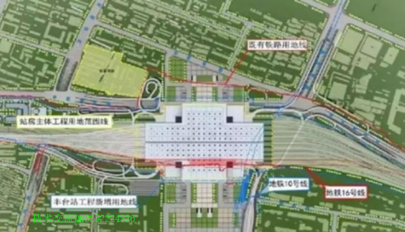
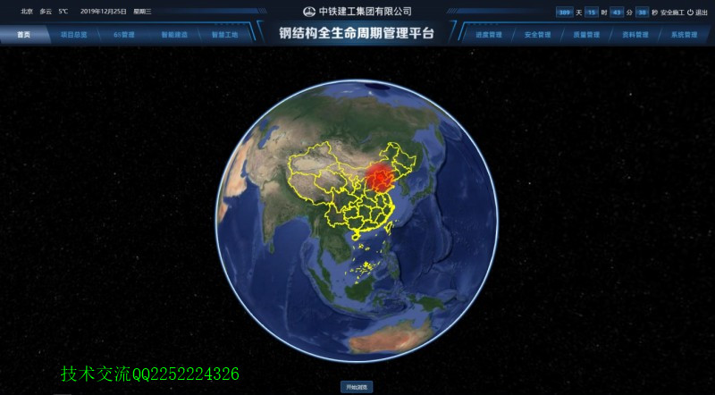
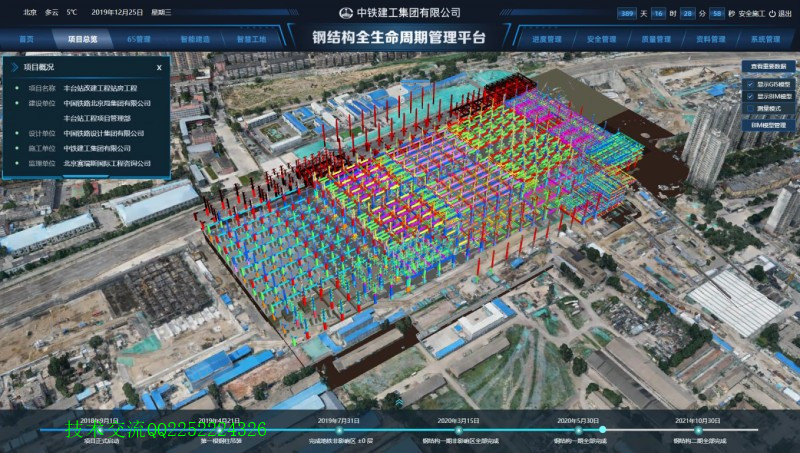
“BIM+GIS钢结构全生命周期管理平台”平台于2019年11月正式上线使用,平台由业务平台、交互平台、移动端三端组成。平台通过BIM技术、信息化技术、GIS技术、物联网技术、集成技术的应用,有效推进钢结构BIM全生命周期智能建造,实现“精品工程、智能丰台”的目标。

2、功能结构
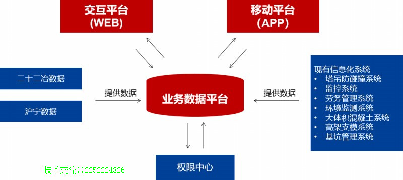
应用了BIM技术、GIS技术、信息化管理等技术于钢结构项目管理中,包括展示平台、业务平台、移动端三部分组成应用重点如下:
(1)实现基于BIM模型查看任意构件设计管理、深化设计、预制加工、物流运输、现场管理、交验管理构件的全生命周期信息,辅助项目管理,直观将移动端、两家业务系统采集的数据直观进行展示。
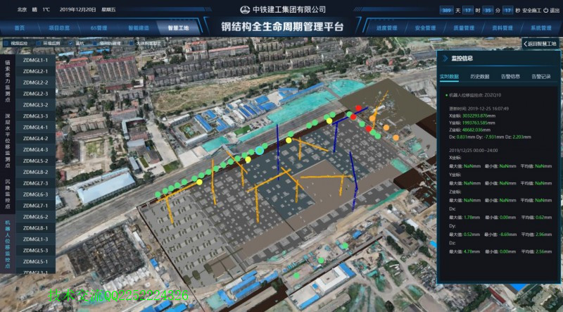
(2)实现了GIS技术、BIM技术与智慧工地融合能够在GIS+BIM场景中随时随地的查看现场智慧工地如监控设备、环境监测、劳务数据、塔吊数据、基坑监测点数据、大体积混凝土测温数据等均与场景对应实现位置信息3维一体。
(3)实现了智慧工厂数据到项目系统中数据的无缝衔接,平台通过接口成功获取了两件钢结构工厂供应商生产阶段数据,实现数据的无缝衔接,数据同步。
部分源码如下:
<!DOCTYPE html>
<html>
<head>
<meta charset="utf-8">
<title data-i18n="resources.title_queryByBounds"></title>
<style type="text/css">
body {
margin: 0;
overflow: hidden;
background: #fff;
100%;
height: 100%
}
#map {
position: absolute;
100%;
height: 100%;
}
#toolbar {
position: absolute;
top: 50px;
right: 10px;
text-align: center;
z-index: 100;
border-radius: 4px;
}
</style>
</head>
<body>
<div id="toolbar" class="panel panel-primary">
<div class='panel-heading'>
<h5 class='panel-title text-center' data-i18n="resources.title_queryByBounds"></h5></div>
<div class='panel-body content'>
<input type="button" class="btn btn-default" data-i18n="[value]resources.text_query" onclick="drawGeometry()"/>
<input type="button" class="btn btn-default" data-i18n="[value]resources.text_input_value_clear" onclick="clearFeatures()"/>
</div>
</div>
<div id="map"></div>
<script type="text/javascript" include="bootstrap,widgets.alert" src="../js/include-web.js"></script>
<script type="text/javascript" exclude="iclient-classic" src="../../dist/classic/include-classic.js"></script>
<script>
var map, local, layer, vectorLayer, control, queryBounds, markerLayer, drawFeature,
style = {
strokeColor: "#304DBE",
strokeWidth: 1,
pointerEvents: "visiblePainted",
fillColor: "#304DBE",
fillOpacity: 0.3
},
host = window.isLocal ? window.server : "https://iserver.supermap.io",
url = host + "/iserver/services/map-world/rest/maps/World";
init();
function init() {
map = new SuperMap.Map("map", {
controls: [
new SuperMap.Control.ScaleLine(),
new SuperMap.Control.Zoom(),
new SuperMap.Control.Navigation({
dragPanOptions: {
enableKinetic: true
}
})]
});
map.addControl(new SuperMap.Control.LayerSwitcher(), new SuperMap.Pixel(42, 80));
layer = new SuperMap.Layer.TiledDynamicRESTLayer("World", url, {
transparent: true,
cacheEnabled: true
}, {maxResolution: "auto"});
layer.events.on({"layerInitialized": addLayer});
vectorLayer = new SuperMap.Layer.Vector("Vector Layer");//新建一个vectorLayer的矢量图层
markerLayer = new SuperMap.Layer.Markers("Markers");//创建一个有标签的图层
drawFeature = new SuperMap.Control.DrawFeature(vectorLayer, SuperMap.Handler.Box, {"handlerOptions": {"cursorCSS": "crosshair"}});
drawFeature.events.on({"featureadded": drawCompleted});
map.addControl(drawFeature);
}
function addLayer() {
map.addLayers([layer, vectorLayer, markerLayer]);
map.setCenter(new SuperMap.LonLat(0, 0), 0);
}
function drawGeometry() {
//先清除上次的显示结果
clearFeatures();
drawFeature.activate();
}
function drawCompleted(obj) {
drawFeature.deactivate();
var feature = obj.feature;
feature.style = style;
vectorLayer.addFeatures(feature);
var queryBounds = feature.geometry.bounds;
var queryParam, queryByBoundsParams, queryService;
queryParam = new SuperMap.REST.FilterParameter({name: "Capitals@World.1"});//FilterParameter设置查询条件,name是必设的参数,(图层名称格式:数据集名称@数据源别名)
queryByBoundsParams = new SuperMap.REST.QueryByBoundsParameters({
queryParams: [queryParam],
bounds: queryBounds
});//queryParams查询过滤条件参数数组。bounds查询范围
queryService = new SuperMap.REST.QueryByBoundsService(url, {
eventListeners: {
"processCompleted": processCompleted,
"processFailed": processFailed
}
});
queryService.processAsync(queryByBoundsParams);//向服务端传递参数,然后服务端返回对象
}
function processCompleted(queryEventArgs) {
var i, j, result = queryEventArgs.result, marker;//queryEventArgs服务端返回的对象
if (result && result.recordsets) {
for (i = 0, recordsets = result.recordsets, len = recordsets.length; i < len; i++) {
if (recordsets[i].features) {
for (j = 0; j < recordsets[i].features.length; j++) {
var f = recordsets[i].features[j];
var point = f.geometry,
size = new SuperMap.Size(44, 33),
offset = new SuperMap.Pixel(-(size.w / 2), -size.h),
icon = new SuperMap.Icon("./images/marker.png", size, offset);
marker = new SuperMap.Marker(new SuperMap.LonLat(point.x, point.y), icon);
marker.sm_capital = f.attributes.CAPITAL;
marker.events.on({
"click": openInfoWin,
"touchstart": openInfoWin, //假如要在移动端的浏览器也实现点击弹框,则在注册touch类事件
"scope": marker
});
markerLayer.addMarker(marker);
}
}
}
}
}
function processFailed(e) {
widgets.alert.showAlert(e.error.errorMsg, false);
}
function clearFeatures() {
vectorLayer.removeAllFeatures();
markerLayer.clearMarkers();
closeInfoWin();
}
var infowin = null;
function openInfoWin() {
closeInfoWin();
var marker = this;
var lonlat = marker.getLonLat();
var contentHTML = "<div style='font-size:.8em; opacity: 0.8; overflow-y:hidden;'>";
contentHTML += "<div>" + marker.sm_capital + "</div></div>";
var size = new SuperMap.Size(0, 33);
var offset = new SuperMap.Pixel(0, -size.h);
var icon = new SuperMap.Icon("./images/marker.png", size, offset);
var popup = new SuperMap.Popup.FramedCloud("popwin",
new SuperMap.LonLat(lonlat.lon, lonlat.lat),
null,
contentHTML,
icon,
true);
infowin = popup;
map.addPopup(popup);
}
function closeInfoWin() {
if (infowin) {
try {
infowin.hide();
infowin.destroy();
}
catch (e) {
}
}
}
</script>
</body>
</html>