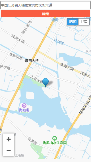
需求:拖拽地图的时候 ,搜索框内容变更时 腾讯地图中心标记点跟着改变

1,在index.html中引入 <script charset="utf-8" src="https://map.qq.com/api/js?v=2.exp&key=换成你申请的key"></script>
key的申请可以点击这里https://lbs.qq.com/,流程大概是:登录->点击开发者信息->点击key管理,创建新密钥,填写相应信息即可
2,在需要使用的页面 html中 加入 <div id="map"></div>
参考链接:
腾讯地图
https://lbs.qq.com/javascript_v2/doc/geocoder.html
https://lbs.qq.com/webDemoCenter/javascriptV2/jsGuide/jsOverview
初版代码如下,加了注释,应该看得懂哈
<template>
  <div>
    <div class="hole">
      <input type="text" v-model="searchAdress" class="searPart" />
      <van-button type="primary" class="searPart" @click="updateDeviceAddress">确定</van-button>
    </div>
    <div id="map" style="100%" :style="{ height: centerHeight }"></div>
    <div id="centerDiv"></div>
  </div>
</template>
<script>
export default {
  data() {
    return {
      searchAdress: '', // 搜索地址
      centerHeight: '', // 地图的高度
      geocoder: null, // 地址解析类。用于在地址和经纬度之间进行转换的服务。
      isDragend: false, // 标识地图  是拖拽 还是搜索
      deviceInfo: { Longitude: '', Latitude: '' }, // 设备原始信息
      marker: null
    }
  },
  methods: {
    // 确定更新机器位置
    updateDeviceAddress() {
      console.log(this.marker.position.lat)
      console.log(this.marker.position.lng)
    },
    init() {
      debugger
      const that = this
      //   初始化地图 设备信息没有经纬度时,设定公司经纬度
      if (that.deviceInfo.Longitude === '' || that.deviceInfo.Latitude === '') {
        that.deviceInfo.Longitude = '119.9690330000' // 经度
        that.deviceInfo.Latitude = '30.2212330000' // 纬度
      }
      //   中心点

      var center = new qq.maps.LatLng(that.deviceInfo.Latitude, that.deviceInfo.Longitude)
      var map = new qq.maps.Map(document.getElementById('map'), {
        center: center,
        draggable: true, // 设置地图可拖拽
        zoom: 13
      })
      // 标记点
      that.marker = new qq.maps.Marker({
        position: center,
        map: map
      })
    // 地址和经纬度之间进行转换服务
      that.geocoder = new qq.maps.Geocoder()
      // 设置服务请求成功的回调函数
      that.geocoder.setComplete(function(result) {

        map.setCenter(result.detail.location)
        if (!that.marker) {
          //   标记不存在 创建
          that.marker = new qq.maps.Marker({
            position: result.detail.location,
            map: map
          })
        } else {
          //   标记已存在 更新
          that.marker.setPosition(result.detail.location)
        }
       //   是拖拽的回调,更新搜索框内容

        if (that.isDragend) {
          that.searchAdress = result.detail.address
        }
      })
      qq.maps.event.addListener(map, 'dragend', function() {
        that.isDragend = true
        var pt = map.getCenter()
        var latLng = new qq.maps.LatLng(pt.lat, pt.lng)
        // 经纬度解析成地址
        that.geocoder.getAddress(latLng)
      })
    },
    // 获取设备信息
    getDeviceInfo() {
      this.$store
        .dispatch('home/deviceInfo', { deviceid: 1540 })
        .then(data => {
          this.deviceInfo = data.data
          this.init()
        })
        .catch(e => {})
    }
  },
  watch: {
    // 监听搜索框内容的变更
    searchAdress(v) {
      //防止拖拽回调更新searchAdress后,再次请求地图服务
      if (!this.isDragend) {
        // 地址解析成经纬度
        this.geocoder.getLocation(v)
      }
      this.isDragend = false
    }
  },
  created() {},
  mounted() {
    this.centerHeight = window.innerHeight - 70 + 'px'
    // 获取设备信息
    this.getDeviceInfo()
  }
}
</script>
<style lang="scss" scoped>
.hole {
  //   padding: 0 5px;
   100%;
  text-align: center;
  .searPart {
     98%;
    height: 30px;
    margin-top: 5px;
  }
}
</style>
<style>
/* 去除地图水印 开始 */
[title='到腾讯地图查看此区域'] {
  display: none !important;
}
#map div div div span {
  display: none !important;
}
/* 去除地图水印 结束 */
</style>