| Time Limit: 1000MS | Memory Limit: 10000K | |
| Total Submissions: 60381 | Accepted: 13610 |
Description
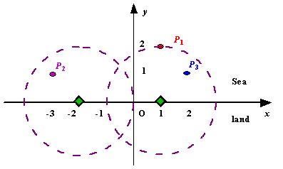
We use Cartesian coordinate system, defining the coasting is the x-axis. The sea side is above x-axis, and the land side below. Given the position of each island in the sea, and given the distance of the coverage of the radar installation, your task is to write a program to find the minimal number of radar installations to cover all the islands. Note that the position of an island is represented by its x-y coordinates.

Figure A Sample Input of Radar Installations
Input
The input is terminated by a line containing pair of zeros
Output
Sample Input
3 2
1 2
-3 1
2 1

1 2
0 2

0 0
Sample Output
Case 1: 2
Case 2: 1
Source
雷达的覆盖范围是一个以R为半径的圆,请用最少的雷达覆盖所有的小岛;当无法覆盖时 输出-1
思路:算出 每个小岛能被覆盖的雷达的圆心,即以小岛为圆心 R为半径 作圆,该圆与X轴的交点:
左交点为x-sqrt(R*R-y*y); 右交点为x+sqrt(R*R-y*y);
按照 左交点 排序,如果i点的左交点在 当前雷达的右边 则需安装一个新雷达,更新雷达
否则 如果 i点的右交点也在当前雷达的左边 则把当前雷达的圆心更新为该点的右交点;
代码
::
#include<stdio.h>
#include<math.h>
#include<string.h>
#include<algorithm>
#include<iostream>
using namespace std;
struct node{
double x;
double y;
}que[1005];
bool cmp(struct node a,struct node b){
return a.x<b.x;
}
int main(){
int n;
double d;
int count=0;
while(scanf("%d%lf",&n,&d)!=EOF){
int sum;
if(n==0&&d==0)
break;
int flag=0;
count++;
for(int i=0;i<n;i++){
double a,b;
scanf("%lf%lf",&a,&b);
que[i].x=a-sqrt(d*d-b*b);
que[i].y=a+sqrt(d*d-b*b);
if(b>d||d<=0||b<0)
flag=1;
}
if(!flag){
sort(que,que+n,cmp);
double temp;
temp=que[0].y;
sum=1;
for(int i=1;i<n;i++){
if(que[i].x>temp){
sum++;
temp=que[i].y;
}
else if(que[i].y<temp){
temp=que[i].y;
}
}
}
if(flag)
printf("Case %d: -1
",count);
else
printf("Case %d: %d
",count,sum);
}
return 0;
}