• 基于三维GIS技术的数字化预案编制管理平台研究


             数字化预案编制管理平台是为规范支队灭火救援预案建设工作,夯实支队信息化作战基础而建设的。系统结合支队信息化技术现状,基于三维GIS技术、物联网技术,新软件理念进行研发,满足了支队及下属大队日常演练与作战指挥需求。系统能够全面提升支队火灾智能化防控水平、实现火灾救援指挥更加精准、智能,提高消防数据应用分析能力。


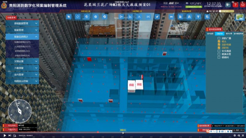
      系统截图1

      下图中,根据颜色级别表示危险度,提醒消防工作者注意自身安全。


      室内预案中,可查看室内消防设施的分布情况。


      室内消防分布设施图


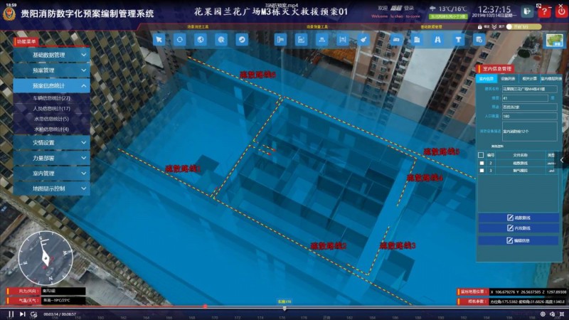
      室内逃生路线图

      此外,可查看预案中派出的消防员、消防员信息以及派出的消防车信息。


      该系统本着实用、操作便捷、智能的原则为消防工作者提供消防灭火辅助工具。后期,系统将接入物联网,系统能够实时传输灾情信息。预案上实现了数据的共享性、决策的智能性、方案的科学性;该系统还可对真实火灾的救援指挥、消防设备部署的合理性进行模拟、研究,支持对救援过程的还原。是消防工作平时演练、战时应急的重要辅助工具。

    
    <!DOCTYPE html>
    <html>
    <head>
    <meta charset="utf-8">
    <title data-i18n="resources.title_animatorTrain"></title>
    <style type="text/css">
            body {
                margin: 0;
                overflow: hidden;
                background: #fff;
                 100%;
                height: 100%
            }
    
            #map {
                position: absolute;
                 100%;
                height: 100%;
            }
    
            #toolbar {
                position: absolute;
                top: 50px;
                right: 10px;
                text-align: center;
                z-index: 100;
                border-radius: 4px;
            }
        </style>
    </head>
    <body>
    <div id="toolbar" class="panel panel-primary">
    <div class='panel-heading'>
    <h5 class='panel-title text-center' data-i18n="resources.title_animatorTrain"></h5></div>
    <div class='panel-body content'>
    <input type="button" class="btn btn-default" data-i18n="[value]resources.btn_play" onclick="startAnimator()"/>&nbsp;
    <input type="button" class="btn btn-default" data-i18n="[value]resources.btn_pause" onclick="pauseAnimator()"/>&nbsp;
    <input type="button" class="btn btn-default" data-i18n="[value]resources.btn_stop" onclick="stopAnimator()"/>&nbsp;
    <input type="button" class="btn btn-default" data-i18n="[value]resources.btn_acceleration" onclick="increaseSpeed()"/>&nbsp;
    <input type="button" class="btn btn-default" data-i18n="[value]resources.btn_deceleration" onclick="decreaseSpeed()"/>&nbsp;
    <input type="button" class="btn btn-default" data-i18n="[value]resources.btn_switchDirection" onclick="setReverseAnimator()"/>&nbsp;
    <input type="button" class="btn btn-default" data-i18n="[value]resources.btn_switchTwinkle" onclick="setGlint()"/>&nbsp;
    <input type="button" class="btn btn-default" data-i18n="[value]resources.btn_switchTails" onclick="setTailr()"/>&nbsp;
    <input type="button" class="btn btn-default" data-i18n="[value]resources.btn_showOrHideTrain" onclick="show()"/>
    </div>
    </div>
    <div id="map"></div>
    <script type="text/javascript" include="bootstrap,widgets.alert" src="../js/include-web.js"></script>
    <script type="text/javascript" exclude="iclient-classic" src="../../dist/classic/include-classic.js"></script>
    <script type="text" id="cartocssStr">
              /*此处定义不同的颜色变量,在后面可以重复用这些颜色值*/
    
            @waterColor:rgb(34,56,78);
            @roadColora:rgb(109,102,91);
            @roadColorb:rgb(109,102,91);
            @railwayColora:rgb(80,80,80);
            @railwayColorb:rgb(137,137,137);
            @vegetationColor:rgb(27,27,27);
            @continentColor:rgb(68,68,68);
            @provinceLineColor:rgb(180,0,0);
    
    
            #China_Railway_L___China::a{
    
            /*每一段的长度为15px,间隔也是15px*/
            line-color:@railwayColora;
            line-2.5;
            }
            #China_Railway_L___China::b{
    
            /*每一段的长度为15px,间隔也是15px*/
            line-dasharray:18,18;
            line-color:@railwayColorb;
            line-2;
            }
            /*底下的地图背景图层*/
    
            #World_Division_pl___China{
            polygon-fill:@waterColor;
            }
    
            /*中国除外的其他国家的图层*/
    
            #World_Continent_pl___China{
            polygon-fill:@continentColor;
            line-1;
            line-color:rgb(180,180,180);
            }
    
            #World_Division_pl___China{
            polygon-fill:@waterColor;
            }
    
    
    </script>
    <script>
        var map, layer, animatorVector, lineVector1, lineVector2,
            host = window.isLocal ? window.server : "https://iserver.supermap.io",
            url = host + "/iserver/services/map-china400/rest/maps/China",
            url2 = host + "/iserver/services/data-DynamicData/rest/data";
        var style1 =
            {
                fillColor: "#ffff00",
                fillOpacity: 0.8,
                strokeOpacity: 0,
                pointRadius: 5
            };
        var style2 =
            {
                fillColor: "#c165f6",
                fillOpacity: 1,
                strokeOpacity: 0,
                pointRadius: 5
            };
    
        init();
    
        function init() {
            if (!document.createElement('canvas').getContext) {
                widgets.alert.showAlert(resources.msg_supportCanvas, false);
                return;
            }
            //初始化地图
            map = new SuperMap.Map("map", {
                controls: [
                    new SuperMap.Control.ScaleLine(),
                    new SuperMap.Control.Zoom(),
                    new SuperMap.Control.Navigation({
                        dragPanOptions: {
                            enableKinetic: true
                        }
                    })],
                projection: "EPSG:3857"
            });
            //初始化图层
            var cartoCssStr = document.getElementById("cartocssStr");
            var cartoCss = cartoCssStr.text;
            var layerNames = ["World_Division_pl@China", "World_Continent_pl@China",
                "China_Province_pl@China", "China_Island@China",
                "China_Capital_Pt@China", "China_Boundary_A"].join(",");
            layerNames = "[" + layerNames + "]";
            layer = new SuperMap.Layer.TiledVectorLayer("China", url, {
                cacheEnabled: true,
                layerNames: layerNames
            }, {useLocalStorage: true, cartoCss: cartoCss});
            layer.events.on({"layerInitialized": addLayer});
    
    
        }
    
        function addLayer() {
            //初始化动画矢量图层
            animatorVector = new SuperMap.Layer.AnimatorVector("Train", {rendererType: "TadpolePoint"}, {
                //设置速度为每帧播放0.02小时的数据
                speed: 0.02,
                //开始时间为0晨
                startTime: 0,
                //结束时间设置为最后运行结束的火车结束时间
                endTime: 39
            });
            lineVector1 = new SuperMap.Layer.Vector("Line1");
            lineVector2 = new SuperMap.Layer.Vector("Line2");
            map.addLayers([layer, lineVector1, lineVector2, animatorVector]);
    
            map.setCenter(new SuperMap.LonLat(12009634.286396, 4258716.5813769), 4);
            //增加数据
            addTrain();
    
        }
    
        //添加火车数据
        function addTrain() {
            var getFeatureParam, getFeatureBySQLService, getFeatureBySQLParams;
    
            getFeatureParam = new SuperMap.REST.FilterParameter({
                name: "Train@DynamicData",
                attributeFilter: "SmID < 2240"
            });
            getFeatureBySQLParams = new SuperMap.REST.GetFeaturesBySQLParameters({
                queryParameter: getFeatureParam,
                datasetNames: ["DynamicData:Train"]
            });
            //返回个数
            getFeatureBySQLParams.toIndex = 2240;
            getFeatureBySQLService = new SuperMap.REST.GetFeaturesBySQLService(url2, {
                eventListeners: {"processCompleted": processCompleted, "processFailed": processFailed}
            });
    
            getFeatureBySQLService.processAsync(getFeatureBySQLParams);
    
        }
    
        function processCompleted(getFeaturesEventArgs) {
            var features, result = getFeaturesEventArgs.result;
            if (result && result.features) {
                features = result.features;
            }
            console.log(features);
    
            //使用数据
            var pointFeatures = [];
            var lines1 = [];
            var lines2 = [];
            var points = [];
            var id = 0;
            for (var i = 0, len = features.length; i < len; i++) {
                var point = features[i].geometry;
                var po = features[i].geometry;
                if (id == features[i].data.FEATUREID) {
                    points.push(po);
                }
                else {
                    id = features[i].data.FEATUREID;
                    lines1.push(
                        new SuperMap.Feature.Vector(
                            new SuperMap.Geometry.LineString(points),
                            {},
                            {
                                stroke: true,
                                strokeColor: "#dddddd",
                                strokeWidth: 3,
                                strokeDashstyle: "solid"
    
                            }
                        )
                    );
                    lines2.push(
                        new SuperMap.Feature.Vector(
                            new SuperMap.Geometry.LineString(points),
                            {},
                            {
                                stroke: true,
                                strokeColor: "#41403f",
                                strokeWidth: 2,
                                strokeDashstyle: "dash"
                            }
                        )
                    );
    
                    points = [];
                }
    
                if (features[i].data.FEATUREID < 151) {
                    var pointFeature = new SuperMap.Feature.Vector(point, {
                        FEATUREID: features[i].data.FEATUREID,
                        TIME: features[i].data.TIME
                    }, style1);
                }
                else {
                    var pointFeature = new SuperMap.Feature.Vector(point, {
                        FEATUREID: features[i].data.FEATUREID,
                        TIME: features[i].data.TIME
                    }, style2);
                }
    
                pointFeatures.push(pointFeature);
            }
            animatorVector.addFeatures(pointFeatures);
            lineVector1.addFeatures(lines1);
            lineVector2.addFeatures(lines2);
    
        }
    
        function processFailed(e) {
            widgets.alert.showAlert(e.error.errorMsg, false);
        }
    
        //开始播放动画
        function startAnimator() {
            animatorVector.animator.start();
        }
    
        //暂停播放动画
        function pauseAnimator() {
            animatorVector.animator.pause();
        }
    
        //停止播放动画
        function stopAnimator() {
            animatorVector.animator.stop();
        }
    
        //减速播放
        function decreaseSpeed() {
            animatorVector.animator.setSpeed(animatorVector.animator.getSpeed() * 0.7);
        }
    
        //正反向播放切换
        function setReverseAnimator() {
            animatorVector.animator.setReverse(!animatorVector.animator.getReverse());
        }
    
        //加速播放
        function increaseSpeed() {
            animatorVector.animator.setSpeed(animatorVector.animator.getSpeed() * 1.5);
        }
    
        //开关闪烁
        function setGlint() {
            animatorVector.renderer.glint = !animatorVector.renderer.glint;
        }
    
        //开关尾巴
        function setTailr() {
            animatorVector.renderer.tail = !animatorVector.renderer.tail;
        }
    
        function show() {
            lineVector1.setVisibility(!lineVector1.getVisibility());
            lineVector2.setVisibility(!lineVector2.getVisibility());
        }
    
    </script>
    </body>
    </html>


    技术交流 省涯 QQ:2252224326 2252224326@qq.com 版权所有 http://blog.sina.com.cn/u/6029512413
  • 相关阅读:
    Contest (树状数组求逆序对)
    树状数组
    unity3D 笔记 (NENE QUEST 制作中用到的函数)
    Ubuntu 安装gnome桌面及vnc远程连接
    Pillow图像处理
    室内场景数据集
    PyTorch踩坑笔记
    进一步了解pip
    一些概念
    损失函数及评价指标
  • 原文地址:https://www.cnblogs.com/shengya/p/14961809.html
Copyright © 2020-2023  润新知