众所周知,现在很多的照相机等软件,拍摄会有选项,是否包含位置信息等。
当然有的人会说,我在微信中查看图片exif信息并没有啊,这是因为你发送到微信服务器的时候,微信帮你完成了保密工作。
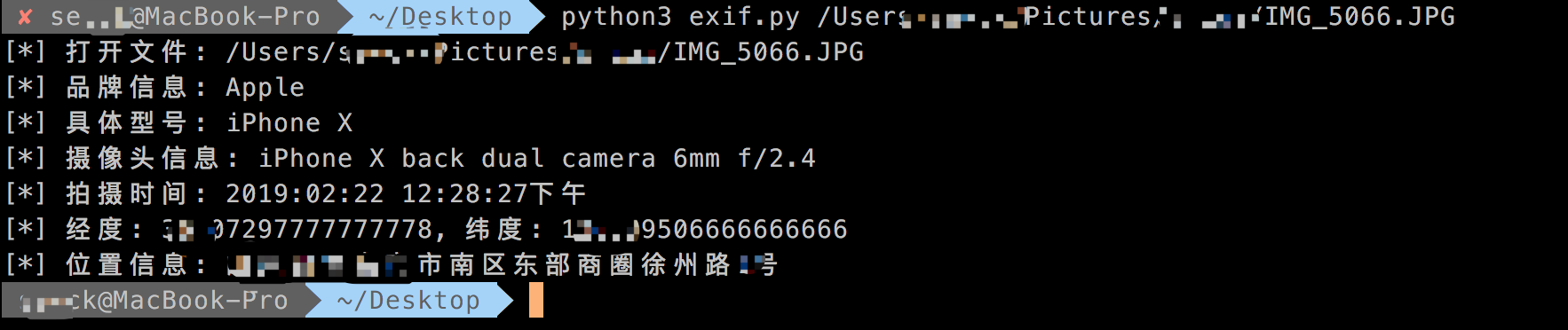
常见的图片中包含了exif信息,我们可以根据exif信息读取GPS坐标、摄像机类型、摄像头信息等。
代码如下:
#!/usr/bin/env python
# coding:utf-8
# @Date    : 2019/3/12 6:48 PM
# @File    : exif.py
# @Author  : sevck (sevck@jdsec.cn)
# @Link    : https://www.javasec.cn
# -------------------------------------------------------------------------

import exifread
import re
import json
import requests
import sys


def latitude_and_longitude_convert_to_decimal_system(*arg):
    """
    经纬度转为小数, 作者尝试适用于iphone6、ipad2以上的拍照的照片,
    :param arg:
    :return: 十进制小数
    """
    return float(arg[0]) + ((float(arg[1]) + (float(arg[2].split('/')[0]) / float(arg[2].split('/')[-1]) / 60)) / 60)


def find_GPS_image(pic_path):
    GPS = {}
    date = ''
    with open(pic_path, 'rb') as f:
        tags = exifread.process_file(f)
        for tag, value in tags.items():
            if re.match('Image Make', tag):
                print('[*] 品牌信息: ' + str(value))
            if re.match('Image Model', tag):
                print('[*] 具体型号: ' + str(value))
            if re.match('EXIF LensModel', tag):
                print('[*] 摄像头信息: ' + str(value))
            if re.match('GPS GPSLatitudeRef', tag):
                GPS['GPSLatitudeRef'] = str(value)
            elif re.match('GPS GPSLongitudeRef', tag):
                GPS['GPSLongitudeRef'] = str(value)
            elif re.match('GPS GPSAltitudeRef', tag):
                GPS['GPSAltitudeRef'] = str(value)
            elif re.match('GPS GPSLatitude', tag):
                try:
                    match_result = re.match('[(w*),(w*),(w.*)/(w.*)]', str(value)).groups()
                    GPS['GPSLatitude'] = int(match_result[0]), int(match_result[1]), int(match_result[2])
                except:
                    deg, min, sec = [x.replace(' ', '') for x in str(value)[1:-1].split(',')]
                    GPS['GPSLatitude'] = latitude_and_longitude_convert_to_decimal_system(deg, min, sec)
            elif re.match('GPS GPSLongitude', tag):
                try:
                    match_result = re.match('[(w*),(w*),(w.*)/(w.*)]', str(value)).groups()
                    GPS['GPSLongitude'] = int(match_result[0]), int(match_result[1]), int(match_result[2])
                except:
                    deg, min, sec = [x.replace(' ', '') for x in str(value)[1:-1].split(',')]
                    GPS['GPSLongitude'] = latitude_and_longitude_convert_to_decimal_system(deg, min, sec)
            elif re.match('GPS GPSAltitude', tag):
                GPS['GPSAltitude'] = str(value)
            elif re.match('.*Date.*', tag):
                date = str(value)
    #print({'GPS_information':GPS, 'date_information': date})
    print('[*] 拍摄时间: '+ date)
    return {'GPS_information': GPS, 'date_information': date}


def find_address_from_GPS(GPS):
    """
    使用Geocoding API把经纬度坐标转换为结构化地址。
    :param GPS:
    :return:
    """
    secret_key = ''
    if not GPS['GPS_information']:
        return '该照片无GPS信息'
    lat, lng = GPS['GPS_information']['GPSLatitude'], GPS['GPS_information']['GPSLongitude']
    print('[*] 经度: ' + str(lat) + ', 纬度: ' + str(lng))
    baidu_map_api = "http://api.map.baidu.com/geocoder/v2/?ak={0}&callback=renderReverse&location={1},{2}s&output=json&pois=0".format(
        secret_key, lat, lng)
    response = requests.get(baidu_map_api)
    content = response.text.replace("renderReverse&&renderReverse(", "")[:-1]
    #print(content)
    baidu_map_address = json.loads(content)
    formatted_address = baidu_map_address["result"]["formatted_address"]
    # province = baidu_map_address["result"]["addressComponent"]["province"]
    # city = baidu_map_address["result"]["addressComponent"]["city"]
    # district = baidu_map_address["result"]["addressComponent"]["district"]
    return formatted_address


img_path = sys.argv[1]
if len(img_path) >= 2:
    print('[*] 打开文件: '+ img_path)
    GPS_info = find_GPS_image(pic_path=img_path)
    address = find_address_from_GPS(GPS=GPS_info)
    print('[*] 位置信息: '+address)
else:
    print('python script.py filename')
需要把secret_key改成你自己的即可。