一、2D世界地图
代码
from pyecharts import options as opts
from pyecharts.charts import Map
from pyecharts.faker import Faker

c = (
    Map(init_opts=opts.InitOpts(width='1500px', height='1200px',bg_color='#E0EEEE'))
    # 加载世界地图实例
    .add("世界地图", [list(z) for z in zip(Faker.country, Faker.values())], "world")
   # 不显示地图标志
    .set_series_opts(label_opts=opts.LabelOpts(is_show=False))
    .set_global_opts(
        # 配置项标题设置
        title_opts=opts.TitleOpts(title="世界地图示例"),
        visualmap_opts=opts.VisualMapOpts(max_=200)
    )
    # 生成超文本文件
    .render("world_map.html")
)
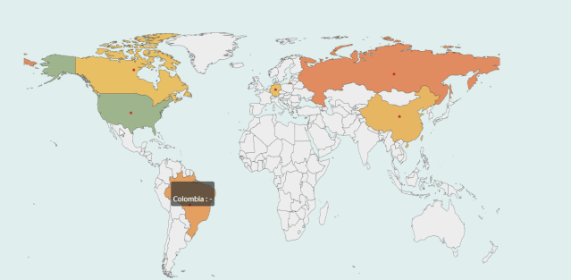
效果图
二、中国3D地图
代码
from pyecharts import options as opts
from pyecharts.charts import Map3D
from pyecharts.globals import ChartType

c = (
    Map3D(init_opts=opts.InitOpts(width='1300px', height='1300px',bg_color='#EBEBEB'))

    .add_schema(
        itemstyle_opts=opts.ItemStyleOpts(
            color="#CDBA96",
            opacity=1,
            border_width=0.8,
            border_color="rgb(62,215,213)",
        ),
        map3d_label=opts.Map3DLabelOpts(
            is_show=True,
            text_style=opts.TextStyleOpts(
                color="#104E8B", font_size=16, background_color="rgba(0,0,0,0)"
            ),
        ),
        emphasis_label_opts=opts.LabelOpts(is_show=True),
        light_opts=opts.Map3DLightOpts(
            main_color="#FFEBCD",
            main_intensity=1.2,
            is_main_shadow=False,
            main_alpha=55,
            main_beta=10,
            ambient_intensity=0.3,
        ),
    )
    .add(series_name="", data_pair="", maptype=ChartType.MAP3D)
    # 全局设置地图属性
    .set_global_opts(
        title_opts=opts.TitleOpts(title="全国行政区划地图"),
        visualmap_opts=opts.VisualMapOpts(is_show=False),
        tooltip_opts=opts.TooltipOpts(is_show=True),
    )
    .render("map3d_china_base.html")
)
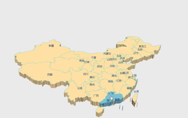
效果图
三、贵州地图
代码
# 写入省份内各地区经纬度
example_data = [
    [[106.70722,26.59820, 1000],[106.63024, 26.64702, 1000]],
    [[104.83023, 26.59336], [106.92723, 27.72545]],
    [[105.30504, 27.29847], [107.52034, 26.29322]],
    [[107.89868, 26.52881], [104.948571, 25.077502]],
    [[105.9462, 26.25367], [109.18099, 27.69066]],
]
# 添加 3D 地图
c = (
    Map3D(init_opts=opts.InitOpts(width='1200px', height='1200px'))
    .add_schema(
        maptype="贵州",
        itemstyle_opts=opts.ItemStyleOpts(
            color="rgb(5,101,123)",
            opacity=1,
            border_width=0.8,
            border_color="rgb(62,215,213)",
        ),
        light_opts=opts.Map3DLightOpts(
            main_color="#fff",
            main_intensity=1.2,
            is_main_shadow=True,
            main_alpha=55,
            main_beta=10,
            ambient_intensity=0.3,
        ),
        view_control_opts=opts.Map3DViewControlOpts(center=[-10, 0, 10]),
        post_effect_opts=opts.Map3DPostEffectOpts(is_enable=True),

    )
    .add(
        series_name="",
        data_pair=example_data,
        type_=ChartType.LINES3D,
        effect=opts.Lines3DEffectOpts(
            is_show=True,
            period=4,
            trail_width=3,
            trail_length=0.5,
            trail_color="#f00",
            trail_opacity=1,
        ),
        label_opts=opts.LabelOpts(is_show=True),
    )
    .set_global_opts(title_opts=opts.TitleOpts(title="Map3D-GuiZhou3D"))
    .render("guizhou_map_3d.html")
)
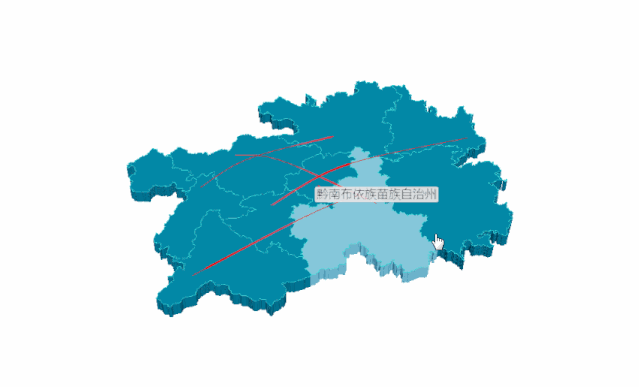
效果图
四、地球村
代码
import pyecharts.options as opts
from pyecharts.charts import MapGlobe
from pyecharts.faker import POPULATION


data = [x for _, x in POPULATION[1:]]
low, high = min(data), max(data)
c = (
    MapGlobe(init_opts=opts.InitOpts(width='1000px', height='1000px',bg_color='#FFFAFA',))
    .add_schema()
    .add(
        maptype="world",
        series_name="World Population",
        data_pair=POPULATION[1:],
        is_map_symbol_show=True,
        label_opts=opts.LabelOpts(is_show=True),
    )
    .set_global_opts(
        title_opts=opts.TitleOpts(title="3D 地球示例"),
        # 设置地球属性
        visualmap_opts=opts.VisualMapOpts(
            min_=low,
            max_=high,
            range_text=["max", "min"],
            is_calculable=True,
            range_color=["lightskyblue", "yellow", "orangered"],
        )
    )
    .render("world_map_3d.html")
)
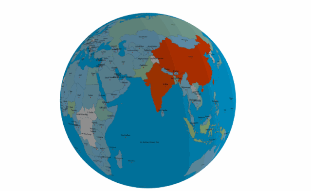
效果图
抄自于:https://mp.weixin.qq.com/s?__biz=MzUyOTk2MTcwNg==&mid=2247489251&idx=1&sn=ee48d73cfe27e222c03e9e7f6f914568&chksm=fa585166cd2fd870cf218767612e39d365ec0847614ccc91a990a5a2d6f23fa3127cf3a6c83b&scene=126&sessionid=1611794067&key=17fda4f84bd4403138da1dfa2fbca071b0fbf84ae9e0f6ef84cb7df86d7731dcdc775adc8aa6646d01bc21a362edd82a738109d920328bcde920cf596dfcab5e021bc5fc73189540b1db6ddc31d0b1ca8002af16cb81f7320a5ccb7773789b0f7df9b3f95e55e6bcd5ca241cc986e3d62a8882306c506d80d5ace361f5b93f84&ascene=1&uin=MjM3MjczMTM2MQ%3D%3D&devicetype=Windows+10+x64&version=6300002f&lang=zh_CN&exportkey=ASpo8%2Bixao4Ke4dpgft6qqY%3D&pass_ticket=Gwod90cS0OFiBskAQSWJiXTZnJNTrI%2FyuOzsthC6wqttHIlg4dcWSi%2FXlIS%2Bhjn4&wx_header=0
参考:https://gallery.pyecharts.org/#/Map3D/README