1. 大数据量的grid栅格。其中使用了d3.min.js 和 turf 的函数。
2. Grid 数据
 1    const geohashlen = 5;
 2         function Grid(geojson) {
 3             let minLng = Infinity, minLat = Infinity, maxLng = -Infinity, maxLat = -Infinity;
 4             const coordinates = geojson.geometry.coordinates[0];
 5             for (let i = 0, len = coordinates.length; i < len; i++) {
 6                 const [lng, lat] = coordinates[i];
 7                 minLng = Math.min(lng, minLng);
 8                 minLat = Math.min(lat, minLat);
 9                 maxLng = Math.max(lng, maxLng);
10                 maxLat = Math.max(lat, maxLat);
11             }
12             this.minLng = minLng;
13             this.minLat = minLat;
14             this.maxLng = maxLng;
15             this.maxLat = maxLat;
16             this.count = 0;
17             this.altitude = 0;
18             this.radius = 1000;
19             this.color = '#fff';
20             this.center = this.getCenter();
21             const [lng, lat] = this.center;
22             this.geohash = geohash.encode(lat, lng, geohashlen);
23         }
3. 处理 csv 数据。
 1 var bars = [];
 2         function addBars(scene) {
 3             d3.csv('https://gw.alipayobjects.com/os/basement_prod/7359a5e9-3c5e-453f-b207-bc892fb23b84.csv', (error, response) => {
 4                 let minLng = 63.34425210104371, minLat = 13.50923035548422, maxLng = 146.75790830392293, maxLat = 57.69160333787326;
 5
 6                 for (let i = 0, len = response.length; i < len; i++) {
 7                     let lng = response[i].lng, lat = response[i].lat;
 8                     lng = parseFloat(lng);
 9                     lat = parseFloat(lat);
10                     // minLng = Math.min(lng, minLng);
11                     // minLat = Math.min(lat, minLat);
12                     // maxLng = Math.max(lng, maxLng);
13                     // maxLat = Math.max(lat, maxLat);
14                     if (minLng <= lng && lng <= maxLng && lat >= minLat && lat <= maxLat) {
15                         lnglats.push([lng, lat, geohash.encode(lat, lng, geohashlen)]);
16                     }
17                 }
18                 // minLng = Math.max(minLng, 63.34425210104371);
19                 // minLat = Math.max(minLat, 13.50923035548422);
20                 // maxLng = Math.min(maxLng, 146.75790830392293);
21                 // maxLat = Math.min(maxLat, 57.69160333787326);
22
23                 const center = new maptalks.Coordinate((minLng + maxLng) / 2, (minLat + maxLat) / 2);
24                 const size = 10000;
25                 const cells = turf.squareGrid([minLng, minLat, maxLng, maxLat], size / 1000, { unit: '' });
26                 const grids = [], radius = size / 2;
27                 for (let i = 0, len = cells.features.length; i < len; i++) {
28                     const grid = new Grid(cells.features[i]);
29                     grid.radius = radius;
30                     gridMap[grid.geohash] = grid;
31                     grids.push(grid);
32                 }
33                 console.log(grids);
34                 const notfinds = [];
35
36                 for (let i = 0, len = lnglats.length; i < len; i++) {
37                     let [lng, lat, key] = lnglats[i];
38                     if (minLng <= lng && lng <= maxLng && lat >= minLat && lat <= maxLat) {
39                         if (gridMap[key]) {
40                             gridMap[key].count++;
41                         } else {
42                             // notfinds.push(key);
43                         }
44                     }
45                 }
46
47                 // console.log(notfinds);
48                 const timer = 'time';
49                 console.time(timer);
50                 let max = -Infinity;
51                 const filterGrids = [];
52                 for (let i = 0, len = grids.length; i < len; i++) {
53                     if (grids[i].count > 0) {
54                         const grid = grids[i];
55                         max = Math.max(max, grid.count);
56                         const color = getColor(grid.count);
57                         grid.color = color;
58                         filterGrids.push(grid);
59                     }
60                 }
61
62                 console.timeEnd(timer);
63                 console.log(max);
64                 const boxs = new Boxs(filterGrids, { center: center }, material, threeLayer);
65                 threeLayer.addMesh(boxs);
66                 console.log(boxs);
67                 bars.push(boxs);
68             });
69
70             initGui();
71             animation();
72         }
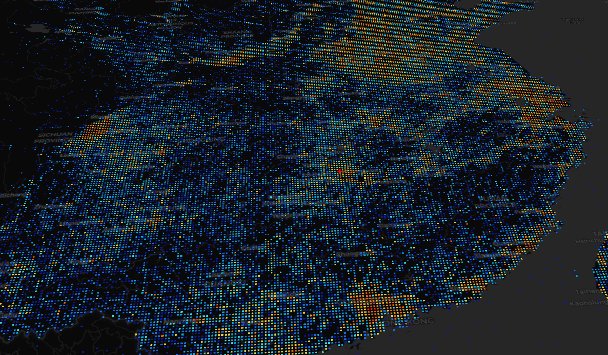
4. 页面显示
5. 源码地址
https://github.com/WhatGIS/maptalkMap/tree/main/threelayer/demo