1 概述
缓冲区分析(Buffer)是对选中的一组或一类地图要素(点、线或面)按设定的距离条件,围绕其要素而形成一定缓冲区多边形实体,从而实现数据在二维空间得以扩展的信息分析方法。缓冲区应用的实例有如:污染源对其周围的污染量随距离而减小,确定污染的区域;为失火建筑找到距其500米范围内所有的消防水管等。
2 缓冲区的基础
缓冲区是地理空间,目标的一种影响范围或服务范围在尺度上的表现。它是一种因变量,由所研究的要素的形态而发生改变。从数学的角度来看,缓冲区是给定空间对象或集合后获得的它们的领域,而邻域的大小由邻域的半径或缓冲区建立条件来决定,因此对于一个给定的对象A,它的缓冲区可以定义为:
P={x | d(x , A)<=r}
(d一般是指欧式距离,也可以是其它的距离,其中r为邻域半径或缓冲区建立的条件)
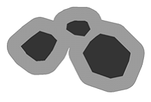
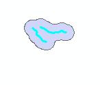
缓冲区建立的形态多种多样,这是根据缓冲区建立的条件来确定的,常用的对于点状要素有圆形,也有三角形、矩形和环形等;对于线状要素有双侧对称、双侧不对称或单侧缓冲区;对于面状要素有内侧和外侧缓冲区,虽然这些形体各异,但是可以适合不同的应用要求,建立的原理都是一样的。点状要素,线状要素和面状要素的缓冲区示意图如下。

3 定制工具的使用
1 打开工程GPBufferLayer\CSharp\GpBufferLayer.sln
2 在VS2005内选择重新生成解决方案
3 开发需要添加工具的工程
4 在ToolBarControl上点右键,选择属性
5 选择条目,点击添加

6 在命令类中选择“自定义工具集”,选择“缓冲区分析”,可通过双击或者拖放到工具条上。
7 运行程序
8 使用“选择要素”命令,选择需要建立缓冲区的要素(点或线)
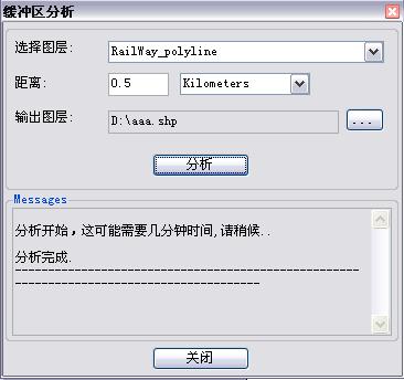
9 点击工具条上的“缓冲区分析按钮”,弹出缓冲区分析对话框
选择要素

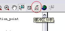
选择缓冲区分析按钮
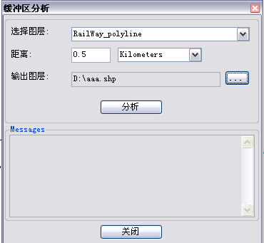
10 选择缓存分析的图层,选择距离及单位,设置输出的图层
11 点击分析按钮,当出现“分析完成”字样时,工作完成
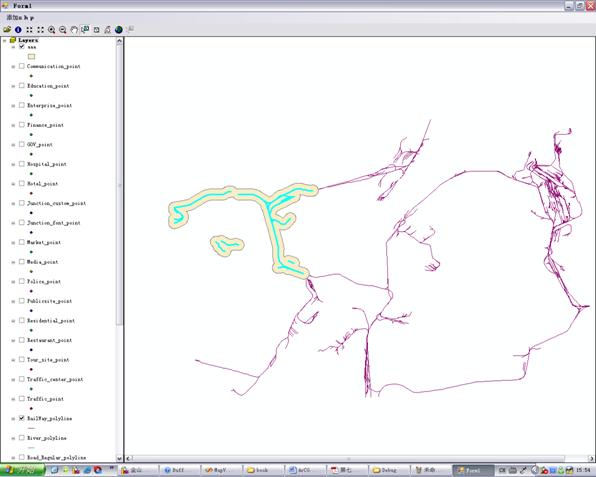
12 这时通过附加新的图层,即可看到结果
4 核心源代码分析
4.1 BufferSelectedLayerCmd.cs
主要完成定制command的相关代码,具体原理可参见《ArcGIS Engine中文开发指南》
4.2 BufferDlg.cs
为缓冲区分析的输入对话框。其中最主要的是“分析”按钮的处理事件。源代码及分析如下:
double bufferDistance;
//转换distance为double类型
double.TryParse(txtBufferDistance.Text, out bufferDistance);
if (0.0 == bufferDistance)
{
MessageBox.Show("Bad buffer distance!");
return;
}
//判断输出路径是否合法
if (!System.IO.Directory.Exists(System.IO.Path.GetDirectoryName(txtOutputPath.Text)) ||
".shp" != System.IO.Path.GetExtension(txtOutputPath.Text))
{
MessageBox.Show("Bad output filename!");
return;
}
//判断图层个数
if (m_hookHelper.FocusMap.LayerCount == 0)
return;
//get the layer from the map
IFeatureLayer layer = GetFeatureLayer((string)cboLayers.SelectedItem);
if (null == layer)
{
txtMessages.Text += "Layer " + (string)cboLayers.SelectedItem + "cannot be found!\r\n";
return;
}
//scroll the textbox to the bottom
ScrollToBottom();
txtMessages.Text += "\r\n分析开始,这可能需要几分钟时间,请稍候..\r\n";
txtMessages.Update();
//get an instance of the geoprocessor
Geoprocessor gp = new Geoprocessor();
gp.OverwriteOutput = true;
//create a new instance of a buffer tool
ESRI.ArcGIS.AnalysisTools.Buffer buffer = new ESRI.ArcGIS.AnalysisTools.Buffer(layer, txtOutputPath.Text, Convert.ToString(bufferDistance) + " " + (string)cboUnits.SelectedItem);
buffer.dissolve_option = "ALL";//这个要设成ALL,否则相交部分不会融合
//buffer.line_side = "FULL";//默认是"FULL",最好不要改否则出错
//buffer.line_end_type = "ROUND";//默认是"ROUND",最好不要改否则出错
//execute the buffer tool (very easy :-))
IGeoProcessorResult results=null;
try
{
results = (IGeoProcessorResult)gp.Execute(buffer, null);
}
catch (Exception ex)
{
txtMessages.Text += "Failed to buffer layer: " + layer.Name + "\r\n";
}
if (results.Status != esriJobStatus.esriJobSucceeded)
{
txtMessages.Text += "Failed to buffer layer: " + layer.Name + "\r\n";
}
//scroll the textbox to the bottom
ScrollToBottom();
txtMessages.Text += "\r\n分析完成.\r\n";
txtMessages.Text += "-----------------------------------------------------------------------------------------\r\n";
//scroll the textbox to the bottom
ScrollToBottom();
5 工程代码下载